Cala Rotja
The “skincare” beach
Cala Rotja is a small cove located next to Cavallería and, despite being slightly overshadowed by her “big sister”, stands as one of the most special beaches in the north of the island.
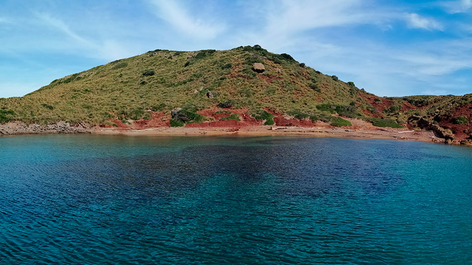
This small cove is especially striking for its diversity of colors: its tip is extremely colorful (hence its name) while, as it enters land, it takes on a more yellowish color. This is due to the fact that the age of the sediments that form it has a time lag of 117 million years.
It is common to find on its shore numerous visitors using its clay soils as face and body masks. This practice may be beneficial for our skin, but it is endangering the soil, which is threatened by the erosion and continuous wear and tear that this practice is causing.
Its geographical position makes Cala Rotja less exposed to the tramontana, and the characteristics of its terrain (with shallow bottoms alternating sand and rocks) make it an ideal place for diving.
A perfect place to enjoy the wildest side of the island and, above all, without the need for long walks to get there. Quite a bargain, isn’t it?

Name: Cala Rotja (or Cala Roja)
Location: North Zone III (40°3.729’N 4°4.589’E)
Distance from Mahón: 24’3 MN ; 31 km
Time from Mahón: 1h 40min by boat (average speed : 15 knots); 32 min by car
Type of beach: Sand
Anchoring with boat: Sand and rock. Open to SW. Low to the N.
Danger access by boat: Low
Posidonia: Yes
Nearest gas station for boats: 7’5 MN; Port of Fornells
SERVICES

PARKING

WALK 460 m

FONDEADERO

PARKING LOT RESTROOMS
Services near Cala Rotja
NO NEARBY SERVICES*.
*We consider them “close” if they are within a radius of 250-300 m approx.
Cala Rotja in Menorca, how to get there?
Very close to Cavallería, the indications to reach it are similar to those of its neighbor.
To get there by road, we will have to leave Mahón by Ronda de Maó, and take the Me-7 to Camí de Tramuntana. We will continue along this road until we find a detour to the right that will take us along the Camides Far road.
On the left we will find the road that will lead us to the parking of Cavallería. Once there, we will follow the path that leads us to this beach (located about 400 meters away) and, from there, we will continue walking along the route that descends to the beach of Cala Roja (approximately another 400 meters).
What to see near Cala Rotja?
Hiking and scuba diving are its two main attractions (along with its wonderful scenery, of course).
The characteristics of its waters, with shallow bottoms where algae and rocks intermingle, make it a perfect place for snorkeling.
On the other hand, its proximity to the beach of Cavallería, makes it easy to join the Camí de Cavalls, to explore the surroundings and discover the magical corners that are hidden in its vicinity. Stage 5 of the route, which runs from Cala Tirant to Binimel-là, passes through Cavallería and, along the way, you can visit wonderful places such as Sanitja (with its cove and defense tower), the beaches of Cala Mica… and, of course, the famous lighthouse of Cap de Cavallería, whose views are breathtaking.
How to get to Cala Rotja by boat?
To reach Cala Rotja by boat, we will have to leave the port of Mahón in a SE direction, leaving the dock to starboard. We will continue through the port until we reach the open sea (up to Punta de Sant Carles).
At this point, we will leave the San Carlos lighthouse to starboard, and continue to port along the coast (heading NE) where we will pass La Mola and Punta de S’Espero, to continue in a NW direction (always sailing with the coast to port).
We will pass Cap Negre, Punta de Sa Galera and, finally, Punta de sa Cudia. On the port side we will see an inlet that leads to Es Grau and in front we will have Illa d’en Colom. We will have to pass it leaving it on the port side and continue in a NW direction until we pass the Cap de Mossen Vives and the Escull den Tortuga. From the bow we will see the Cap de Favàritx and its unmistakable lighthouse.
Skirting the Favàritx point, we will sail in a NW direction until we see the Addaia islands. We will pass them on the port side and continue until we reach Punta Pantinat.
We will go around it and sail in a NW direction (passing Punta de na Guillemassa and Punta des Morter) until we reach Cap de Cavallería. We will border it passing between Illa d’els Porros (which will be on the starboard side) and Illot des Pas (which will be on the port side).
Once past the channel between the two, we descend in a southerly direction, leaving Cap d’es Vernis on the port side. Following the coastline of this cape, we will find Cala Roig on the port side (just before reaching Platja de Cavallería, which is located to the south of it).
Do you want to go to Cala Rotja by boat?


